Ontario, Canada
100%
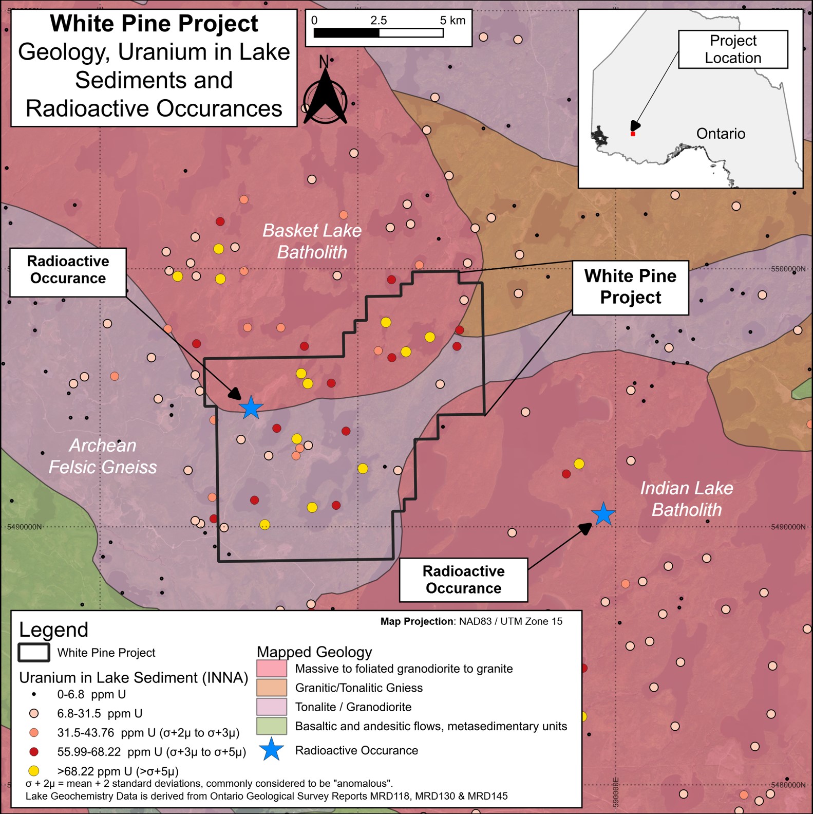
White Pine is supportive of intrusive-type uranium (an example is Rössing in Namibia) with two granitic rock batholiths intruded into an area of gneiss1.
Statistical analysis completed over a lake sediment sampling study containing more than 4,000 samples2 and covering approximately 15,000 km2 delineates White Pine as a prospective uranium target when plotting the 99.5% percentile uranium assay data.
Very highly anomalous and extremely anomalous uranium in lake sediments compared with regional data, including values of up to 149 ppm uranium and nine samples with uranium values in excess of five standard deviations above mean.
Radiometric survey results3 indicate an intense radiometric signature over the property, extending at least 14 km. This area aligns closely with the anomalous uranium-in-lake sediments described above.
Minimal fieldwork to date, with no systematic or modern sampling.
The project has multiple important factors underlining its prospectivity, including:
The White Pine Project is located 25 kilometres northwest of the town of Ignace. There is excellent access to the project along a network of graded roads which connect to the Trans Canada Highway situated seven kilometres to the south. Commercial logging activities provide extensive, ready-made access. Partially overgrown trails remain accessible to all-terrain vehicles such as quad bikes and snowmobiles.
Initial reconnaisance has recorded observations on rock type and extent of outcrop, terrain and forest cover and taking surface radiometric measurements to ground check features identified from existing airborne geophysical data. The work, although preliminary, provides vital input for the planning of comprehensive and systematic fieldwork.
A variety of outcropping geology has been observed, including predominantly coarse-grained to pegmatitic leucogranites and pegmatites consistent with intrusive-style uranium deposits supporting White Pine's underlying prospectivity. Granite outcrops are regularly observed with a glacially polished 'whale back' appearance. Elsewhere, steep bluffs are noted, which are inferred to be related to fault structures; such fault structures can help control mineralisation or distribute geochemical anomalies and thus understanding will be a key factor in future exploration.
Historical high resolution airborne radiometric survey report data includes a series of radiometric maps that cover the entire area of the White Pine claims. Maps include equivalent uranium concentration and ratio of equivalent uranium to equivalent thorium which are providing the focus of analysis of radiometric anomalies identified across the Project. Ratios of equivalent uranium to equivalent thorium are recorded that support a primary, local uranium source in bedrock.
Additionally, the Company has gained access to a high-resolution magnetic survey that covers the White Pine claims area. The report includes a total magnetic intensity map and a processed first vertical derivate map. The first vertical derivative provides sharpened anomalies which outline two major structural trends. Further analysis is ongoing.
The Company has recently compiled high-resolution LiDAR data over the project area sourced from the Ontario GeoHub. LiDAR is a remote sensing method that gives detailed elevation data of the ground, effectively seeing through vegetation and forest cover. This data is of sufficient resolution to give meaningful input to geological interpretations (especially structure) as well as delineating areas of outcrop and access.