Projects

Pearl

Location

Ontario, Canada

Ownership

100%

Minerals

Lithium
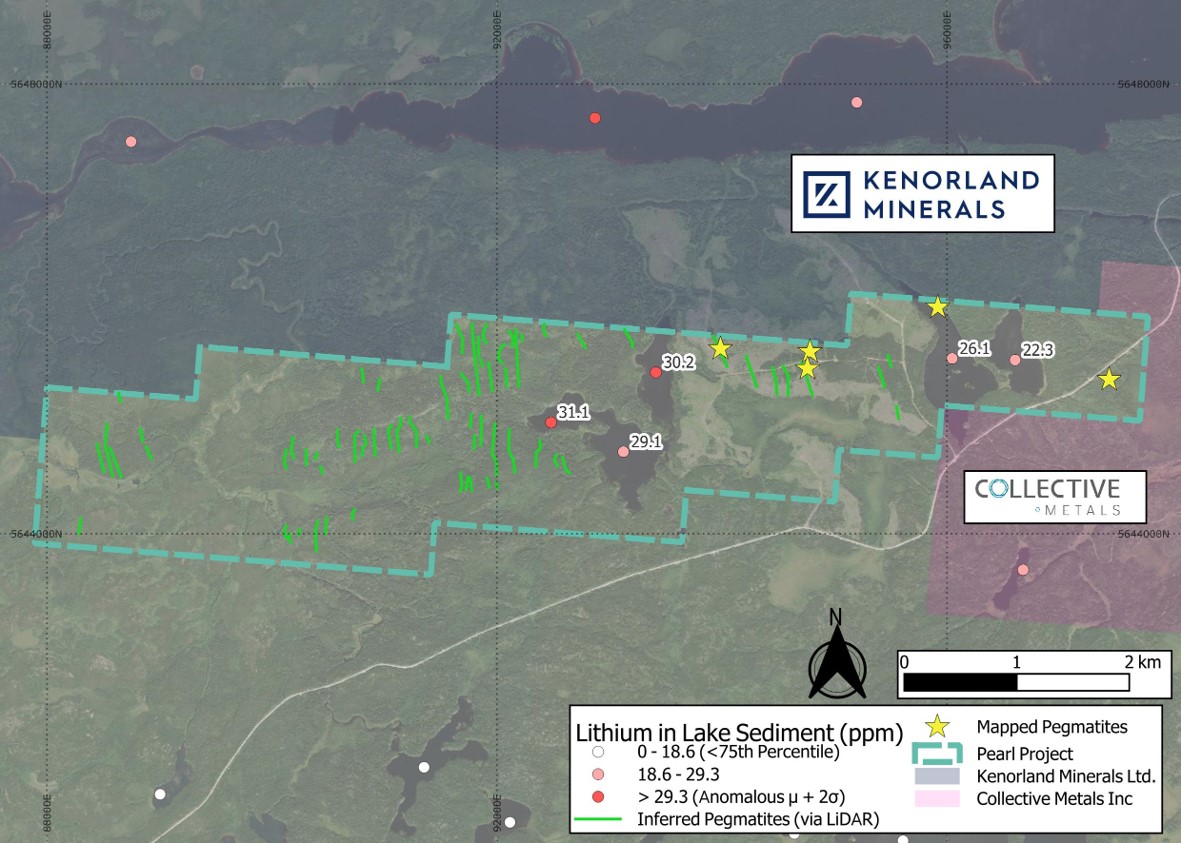
Pearl map
  • The Pearl claims cover 1,475 hectares encompassing multiple untested inferred pegmatites identified though LiDAR imagery1.

  • The inferred pegmatites have the same orientation and similar outcrop to historically mapped pegmatites2 in the north and east of the property.

  • Proximal to waterbodies where lake sediments are recorded as having anomalous or highly elevated results3,4 for lithium and elements associated with LCT pegmatites5.

1: Ontario Ministry of Natural Resources and Forestry, accessed 24 March 2025, Forest Resources Inventory leaf-on LiDAR, Ontario GeoHub <https://geohub.lio.gov.on.ca/
2: Fenwick, K.G., 1967, Whitemud Lake area (Fredart-Whitemud lakes area), District of Kenora (Patricia Portion), Ontario Geological Survey, P0412
3: Ontario Geological Survey, 2001, Lake Sediment Analytical Data for the Sioux Lookout-Bamaji Lake Area: Operation Treasure Hunt, MRD088
4: Ontario Geological Survey, 2002, Lake Sediment Geochemical Data from the Perrault Falls Survey Area, Northwestern Ontario: Operation Treasure Hunt, MRD106
5: Bradley, D.C., McCauley, A.D., Stillings L.M., 2017, Mineral-Deposit Model for Lithium-Cesium-Tantalum Pegmatites, USGS.
Learn More

Iva

Location

Ontario, Canada

Ownership

100%

Minerals

Lithium
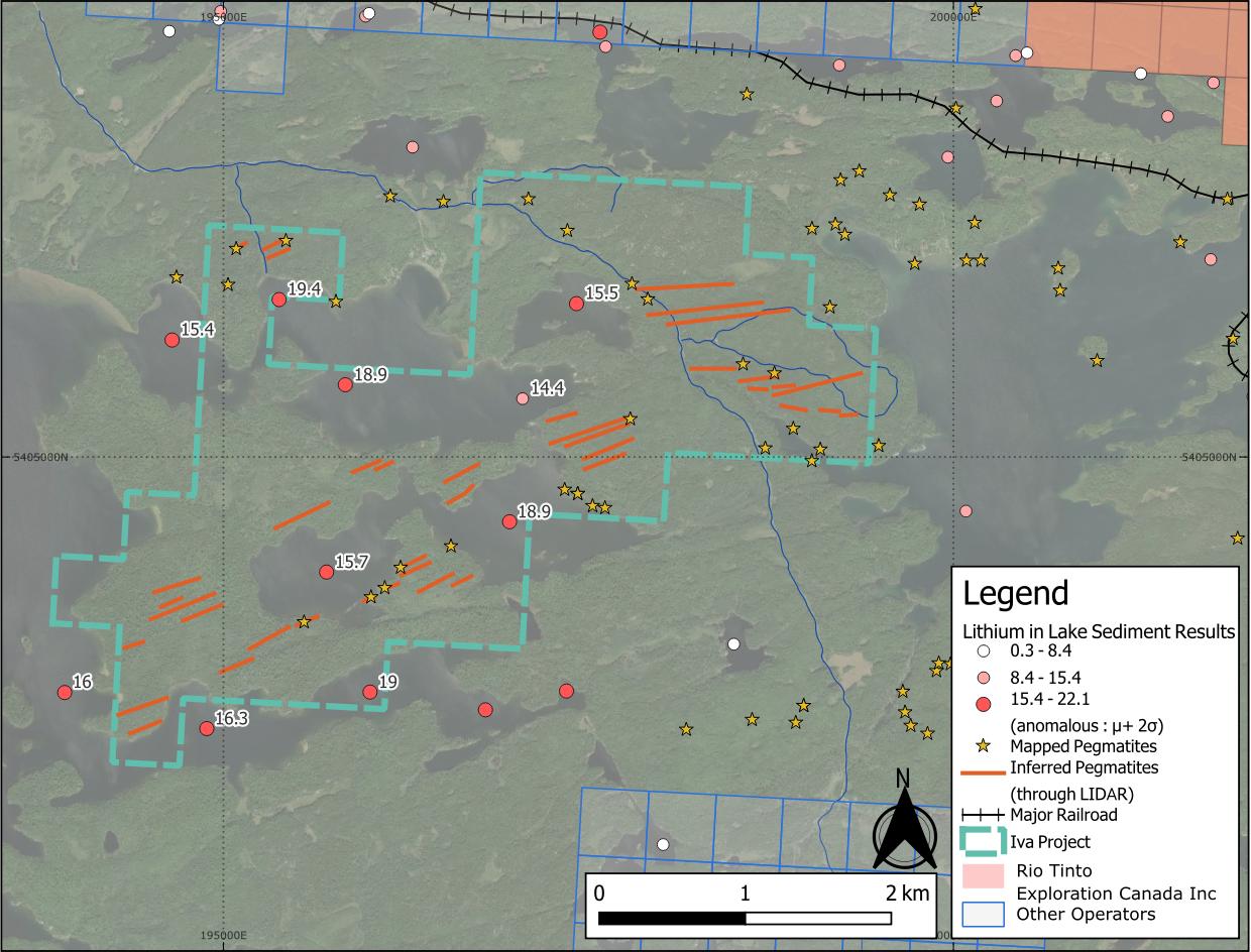
Iva map
  • Iva is a 642 hectare property centred on anomalous lithium, caesium and beryllium lake sediment1,2 assay results.

  • Positioned at the interface between granite and metasedimentary lithologies3, a favourable setting for LCT pegmatites4.

  • Nearby lithium projects highlight regional potential: Patriot Lithium's Bull Project sits 11 km to the east, and the Niobe-Nym Lakes LCT pegmatites lie 20 km away – both are associated with the same intrusion as Iva.

1: Dyer, R.D., 1999, Lake Sediment and Water Geochemistry Data from the Atikokan-Lumby Lake Area, Northwestern Ontario (MRD043)
2: Jackson, J.E., 2001, Lake Sediment and Water Geochemical Data from the Shebandowan Lake Area, Northwestern Ontario (MRD076)
3: Pirie, J. 1978, Ontario Geological Survey Crooked Pine Lake, Rainy River District Geological Map #M2405
4: Bradley, D.C., McCauley, A.D., Stillings L.M., 2017, Mineral-Deposit Model for Lithium-Cesium-Tantalum Pegmatites, USGS.
 
Learn More

Burrows Projects

Location

Ontario, Canada

Ownership

100%

Minerals

Lithium
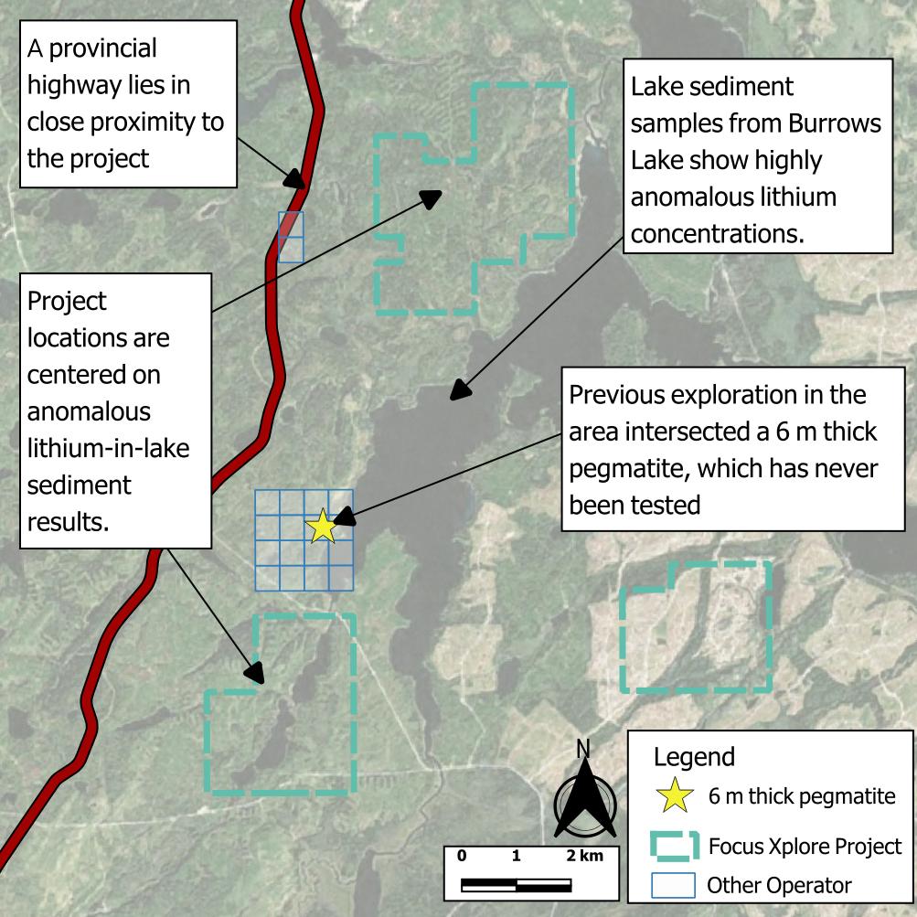
Burrows Projects map
  • The Burrows Projects comprise three under-explored properties covering 2,400 hectares in an area outlined by the Ontario Survey as a target for grassroots lithium exploration1.

  • Elevated lithium and caesium are known from deep lake sediment assays and the local geology is recognised as having potential to host lithium-bearing pegmatites2.

  • Historic drilling in the 1970s3,4 within 2 km of the projects hit 5 metre-thick pegmatites that were never assayed for lithium.

1: Paju, G.F. 2019. Beardmore to Geraldton: A grassroots look for lithium in a prolific gold camp; in Report of Activities 2018, Resident Geologist Program, Thunder Bay North Regional Resident Geologist Report: Thunder Bay North District; Ontario Geological Survey, Open File Report 6352, p.55-71.
2: Bradley, D.C., McCauley, A.D., Stillings L.M., 2017, Mineral-Deposit Model for Lithium-Cesium-Tantalum Pegmatites, USGS.
3: Hudson Bay Exploration & Development Co Ltd, 1973, Hudson Bay Exploration And Development Company Limited, Final Report On Exploration, Exploration Assistance Agreement. Geraldton - Beardmore Area, Thunder Bay Mining Division - Ontario, Longlac Project; Contract No. Gb-25 (Assessment Report Number: 42E15NE8354 ).
4: Moly-Ore Mines Ltd, 1965, Report on Diamond Drilling Program on Moly Ore Mines Limited, Burrows Lake Property, Area of Burrows Lake, Port Arthur Mining Division, (Assessment Report Number: 42E15NW0002).


Learn More

Bay Road

Location

Ontario, Canada

Ownership

100%

Minerals

Magnet Metals (REE)
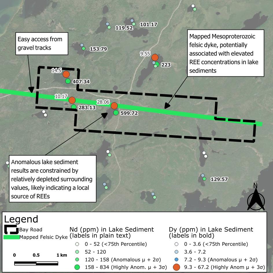
Bay Road map
  • Bay Road covers 425 hectares directly south of the fertile White Otter Batholith.

  • The property is centred on 6 km of felsic intrusive rock1 mapped by the Ontario Geological Survey.

  • The intrusive feature has a spatial relationship with highly anomalous REEs2,3,4 in lake sediment assays, specifically “magnet metals” dysprosium and neodymium – used in the manufacture of modern permanent magnets.

1: Santaguida, F., 2001, Ontario Geological Survey,. Precambrian Geology Compilation Series - Quetico Sheet, 2000 Series Map (M2663).
2: Dyer, R.D., 1999, Lake Sediment and Water Geochemistry Data from the Atikokan-Lumby Lake Area, Northwestern Ontario (MRD043).
3: Jackson, J.E. 2003, Lake Sediment Geochemical Data from the Ignace Survey Area, Northwestern Ontario: Operation Treasure Hunt (MRD118).
4: Dyer, R.D., Burke, H.E. 2012, Lake Sediment and Water Geochemical Data from the Mine Centre Area, Northwestern Ontario (MRD296).
Learn More